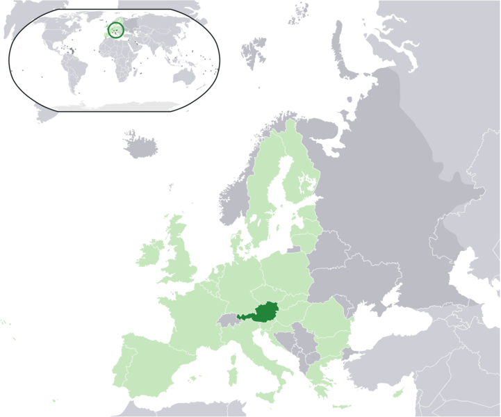
File:Location Austria EU Europe.png
Dzedzeme

Hafi nakpɔ alesi eƒe lolome le :721 × 600 pixelwo. Other resolutions: 289 × 240 pixelwo | 577 × 480 pixelwo | 923 × 768 pixelwo | 1,231 × 1,024 pixelwo | 2,056 × 1,710 pixelwo.
Gbale adoduia (2,056 × 1,710 pixels, file size: 320 KB, MIME type: image/png)
Nutsɔ ʋuvayiwo
Tia ŋkeke/gaƒoƒo ɖeka ne wòadi be yea kpɔ axa sia ƒe tata le ɣemaɣi
| Ŋkeke/Gaƒoƒo | Nɔnɔmetata sue aɖe | Goglome | Ezãla | Comment | |
|---|---|---|---|---|---|
| fifia | 21:22, 18 Dasiamime 2017 |  | 2,056 × 1,710 (320 KB) | Kontrollstellekundl | added Croatia to EU |
| 21:18, 18 Dasiamime 2017 |  | 2,056 × 1,710 (320 KB) | Kontrollstellekundl | added Croatia | |
| 01:14, 18 Masa 2007 |  | 2,056 × 1,710 (174 KB) | Quizimodo~commonswiki | image (updated) | |
| 09:42, 17 Masa 2007 |  | 2,056 × 1,710 (226 KB) | Quizimodo~commonswiki | image (tweaked) | |
| 07:28, 17 Masa 2007 |  | 2,056 × 1,710 (226 KB) | Quizimodo~commonswiki | image (tweaked) | |
| 07:18, 17 Masa 2007 |  | 2,056 × 1,710 (226 KB) | Quizimodo~commonswiki | {{Information |Description=Location map: Austria (dark green) / European Union (light green) / Europe (dark grey); inspired by and consistent with general country locator maps by User:Vardion, et al |Source=self-made |Date=17 June 2007 |Author= [[User:Qui |
Nyatakagbaa zazã
Axa aɖeke medo ka kple fael sia o.
Xexe me godoo ƒe agbale zaza
The following other wikis use this file:
- Ezã az.wiktionary.org
- Ezã ceb.wikipedia.org
- Ezã dz.wikipedia.org
- Ezã en.wikipedia.org
- Ezã eu.wiktionary.org
- Ezã hu.wikipedia.org
- Ezã it.wikibooks.org
- Ezã ja.wikipedia.org
- Ezã ja.wikivoyage.org
- Ezã kbp.wikipedia.org
- Ezã kn.wikipedia.org
- Ezã nl.wikipedia.org
- Ezã pi.wikipedia.org
- Ezã pl.wiktionary.org
- Ezã pt.wikipedia.org
- Ezã ru.wikipedia.org


