
File:Koppen-Geiger Map Africa present.svg

Size of this PNG preview of this SVG file: 800 × 474 pixelwo. Other resolutions: 320 × 190 pixelwo | 640 × 379 pixelwo | 1,024 × 607 pixelwo | 1,280 × 758 pixelwo | 2,560 × 1,516 pixelwo | 1,435 × 850 pixelwo.
Gbale adoduia (SVG file, nominally 1,435 × 850 pixels, file size: 2.4 MB)
Nya kpui aɖe
| Numeɖeɖe |
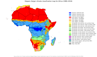
English: Köppen–Geiger climate classification map for Africa
العربية: خريطةٌ مفصّلةٌ تُصنّف أنواع المناخات في مختلفِ مناطق قارّة أفريقيا. |
| Ŋkeke | |
| Nyatakatsoƒe | "Present and future Köppen-Geiger climate classification maps at 1-km resolution". Nature Scientific Data. DOI:10.1038/sdata.2018.214. |
| Ewɔla | Beck, H.E., Zimmermann, N. E., McVicar, T. R., Vergopolan, N., Berg, A., & Wood, E. F. |
Licensing
This file is licensed under the Creative Commons Attribution 4.0 International license.
- You are free:
- na ma – to copy, distribute and transmit the work
- to remix – to adapt the work
- Under the following conditions:
- attribution – You must give appropriate credit, provide a link to the license, and indicate if changes were made. You may do so in any reasonable manner, but not in any way that suggests the licensor endorses you or your use.
| Camera location | | View this and other nearby images on: OpenStreetMap |
|---|
Nutsɔ ʋuvayiwo
Tia ŋkeke/gaƒoƒo ɖeka ne wòadi be yea kpɔ axa sia ƒe tata le ɣemaɣi
| Ŋkeke/Gaƒoƒo | Nɔnɔmetata sue aɖe | Goglome | Ezãla | Comment | |
|---|---|---|---|---|---|
| fifia | 23:47, 9 Dzove 2020 | | 1,435 × 850 (2.4 MB) | AndreyKva | Optimized using SVGO. |
| 03:32, 26 Adeɛmekpɔxe 2018 |  | 1,435 × 850 (3.81 MB) | NVergopolan | {{Information |Description={{en| Köppen–Geiger climate classification map for Africa}}|date=2018-11-06|source={{cite journal | title=Present and future Köppen-Geiger climate classification maps at 1-km resolution | journal=Nature Scientific Data |doi=10.1038/sdata.2018.214}}|author=Beck, H.E., Zimmermann, N. E., McVicar, T. R., Vergopolan, N., Berg, A., & Wood, E. F.|permission=|other_versions=|other_fields=}}{{Cc-by-4.0}}{{Location|1.25920455848|19.0676026668}}[[Category:Köppen-Geiger Climat... |
Nyatakagbaa zazã
Axa sia ku ɖe agbalẽ sia ŋu:
Xexe me godoo ƒe agbale zaza
The following other wikis use this file:
- Ezã ar.wikipedia.org
- Ezã ast.wikipedia.org
- Ezã en.wikipedia.org
- Ezã es.wikipedia.org
- Ezã fr.wikipedia.org
- Ezã gl.wikipedia.org
- Ezã ha.wikipedia.org
- Ezã ig.wikipedia.org
- Ezã lt.wikipedia.org
- Ezã ne.wikipedia.org
- Ezã sl.wikipedia.org
- Ezã sr.wikipedia.org
- Ezã tn.wikipedia.org
- Ezã zh.wikipedia.org