
File:Argentina topo blank.jpg

Hafi nakpɔ alesi eƒe lolome le :445 × 599 pixelwo. Other resolutions: 178 × 240 pixelwo | 357 × 480 pixelwo | 571 × 768 pixelwo | 761 × 1,024 pixelwo | 1,600 × 2,153 pixelwo.
Gbale adoduia (1,600 × 2,153 pixels, file size: 565 KB, MIME type: image/jpeg)
| Numeɖeɖe |
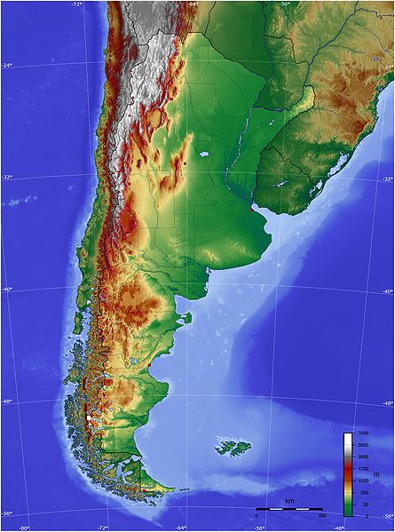
Español: Mapa de Argentina con su relieve
English: Map of Argentina with its terrain levels |
||||||||||
| Ŋkeke | 9/06/2006 | ||||||||||
| Nyatakatsoƒe | See below | ||||||||||
| Ewɔla | Captain Blood | ||||||||||
| Mɔɖeɖe (Fael sia ƒe gbugbɔgazã) |
|

Nutsɔ ʋuvayiwo
Tia ŋkeke/gaƒoƒo ɖeka ne wòadi be yea kpɔ axa sia ƒe tata le ɣemaɣi
| Ŋkeke/Gaƒoƒo | Nɔnɔmetata sue aɖe | Goglome | Ezãla | Comment | |
|---|---|---|---|---|---|
| fifia | 21:45, 13 Dame 2009 | | 1,600 × 2,153 (565 KB) | Keysanger | reverted. (Deleted yellow line in the Straits of Magellan, added the definitive end of the controversial border at the Beagle Channel and marked with a white box the (last) undefined border zone as agreed both countries.) |
| 04:10, 5 Dame 2009 |  | 1,600 × 2,153 (867 KB) | Dexxter | Reverted to version as of 18:57, 9 June 2006 | |
| 20:13, 4 Masa 2008 |  | 1,600 × 2,153 (565 KB) | Keysanger | Argentina topo deleted yellow line in the Straits of Magellan, added the definitive end of the controversial border at the Beagle Channel and marked with a white box the (last) undefined border zone as agreed both countries. [[Category:[[Category:Topograp | |
| 18:57, 9 Masa 2006 |  | 1,600 × 2,153 (867 KB) | Captain Blood~commonswiki | {{Bild-GFDL-GMT}} |
Nyatakagbaa zazã
Axa sia ku ɖe agbalẽ sia ŋu:
Xexe me godoo ƒe agbale zaza
The following other wikis use this file:
- Ezã bg.wikipedia.org
- Ezã bn.wikipedia.org
- Ezã ca.wikipedia.org
- Ezã ckb.wikipedia.org
- Ezã dz.wikipedia.org
- Ezã el.wikipedia.org
- Ezã en.wikipedia.org
- Ezã eo.wikipedia.org
- Ezã es.wikipedia.org
- Ezã eu.wikipedia.org
- Ezã fa.wikipedia.org
- Ezã fi.wikipedia.org
- Ezã fr.wikipedia.org
- Ezã gcr.wikipedia.org
- Ezã hu.wikipedia.org
- Ezã hy.wikipedia.org
- Ezã incubator.wikimedia.org
- Ezã io.wikipedia.org
- Ezã it.wikipedia.org
- Ezã ja.wikipedia.org
- Ezã ka.wikipedia.org
- Ezã kbd.wikipedia.org
- Ezã ko.wikipedia.org
- Ezã ml.wikipedia.org
- Ezã ms.wikipedia.org
- Ezã mt.wikipedia.org
- Ezã pl.wikipedia.org
- Ezã pt.wikipedia.org
View more global usage of this file.